Collection:
Juneau—Douglas City Museum
Object ID:
2004.58.016 A—F
Accession#:
2004.58
Credit Line:
Donated by Brian Wallace.
Object Name:
Print, Photographic
Title:
Photograph album of tideland fill, circa 1940
Photographer:
Wallace, Amos
Place:
Juneau
Date:
11/01/1940
Description:
A is album page. B to F are black and white photographs, 4.75 by 3.25 inches. All photos horizontally oriented unless otherwise noted.
A — Black paper album page with two holes proper right side. One photo affixed to front, two loose. One photo affixed to back, one loose. Captions printed in white ink beside photos to which they refer. Missing photos on back originally had caption "Fill Finis".
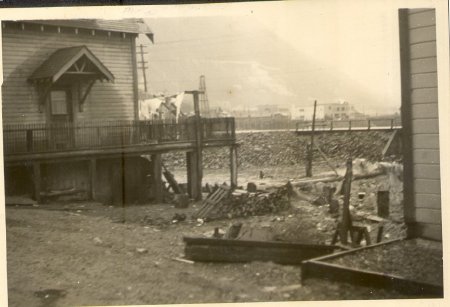
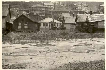
B — Photograph, large building in upper proper right quadrant surrounded by fenced—in deck on pilings. Corner of another building visible along proper left edge of photo. Tidal flats strewn with broken pilings and debris in foreground and extending back between two buildings. Road (Willoughby Avenue) crosses photo horizontally in background, with other buildings (including a large white flat—roofed one) and Cropley's pile driver alongside and beyond it. Mountains in distance. Caption to proper right of place where photo was originally affixed reads "Indians' occupancy at Capital City has never been officially surveyed. But Indians have Skookum paper title".
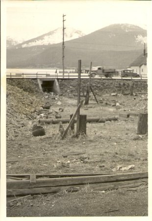
C — Photograph, vertical orientation, loose from album. Tidal flats with lumber, pilings, and other debris; road on rock—fill bank in background with culvert passing underneath. Two vehicles at proper left end of road facing in opposite directions. Part of a white building (Salvation Army) visible at proper left edge of photo. Douglas mountains in distance.
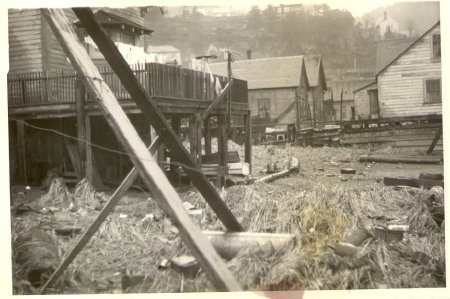
D — Photograph, large house in upper proper right corner same as in B, surrounded by fenced—in deck. Grass strewn with debris in foreground. Two wooden beams directly in front of camera, each with one end on ground, cut diagonally across photo, leaning toward upper proper right corner. Village houses in background, with hillside (more houses on it) beyond that. Caption to proper left of photo reads "West End Before".
E — Photograph, Village houses, Federal School building at center. Other buildings on hillside in background. Dirt road runs proper left to proper right in foreground; beyond road, ground around houses is unevenly covered with piles of dirt. Caption below photo and extending under place where next photo was previously affixed reads "Dirt surfacing".
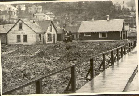
F — Photograph (loose from album), boardwalk with railing at side of road extends across lower proper left corner of photo, with dirt ground cover on proper right. Several houses on dirt; of closest two to photographer, proper right house is white and proper left house is dark. Vehicle parked facing photographer in between two houses. More buildings visible in background and on hillside.
Notes:
B) Young/Nelson house was the house with the deck at the left (Karl Nelson and Judy Franklet) .
C — As per Marie Olson: Gold Creek.
D — As per Marie Olsen, one of the houses in this photo is possibly the Alice Young house. Yes, Karl Nelson and Judy Franklet say this is the Young/ Nelson house.
E — As per Marie Olsen, house on proper left of Federal School (referring to house on proper left and immediately in front of school, or house on proper left and somewhat behind, on hill?) was occupied by Mrs. Viloria. Also, there were stairs up the hill (one set visible in background of this photo) in 2 places. As per Willette Janes, apartment building in background was "Seaview."
Karl Nelson and Judy Franklet say Jacobs' house was the middle house on the right. Wanamake house was the first on the right. Dan Brown in the left house.
People:
Wallace, Brian
Wallace, Amos
Young, Alice
Viloria
Wallace, Amos
Young, Alice
Viloria
Search Terms:
Architecture
Archival
Auke
Cityscape
Ethnographic
Federal
Landscape
Native
Photograph
School
Tlingit
Transportation
Archival
Auke
Cityscape
Ethnographic
Federal
Landscape
Native
Photograph
School
Tlingit
Transportation
